CAHOKIA MOUNDS
By William I. Woods
<<<<<<<<<<<<<<<<<<<<<<<<<<<<<<<<Click aquí para leer el artículo en español>
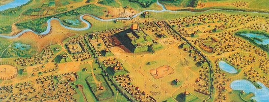
Cahokia Mounds is an archaeological site occupying some 13 km2 on the Middle Mississippi River flood plain near East St. Louis, Illinois, USA. Cahokia, which flourished for approximately four centuries (c. AD 950-1350) and had a peak population of some 15,000 individuals or more, was the most extensive urban center in prehistoric America north of Mexico and the primary center of the Middle Mississippian culture. It was later named Cahokia for an indigenous group that inhabited the area in the 18th century. No records exist on what its original inhabitants called themselves.
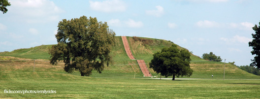
Skilled administrators and a large labor force were needed to plan, build, and maintain the site. It was laid out with clearly defined zones for administrative and ceremonial functions, elite compounds, residential neighborhoods, and even suburbs—all with similar orientations on the cardinal directions. Among the largest features are an enormous central plaza encompassing nearly 16 ha and numerous immense earthworks, including the pyramidal Monks Mound, the largest prehistoric earthen structure in the Western Hemisphere. Attaining a height of over 30 m , Monks covers over 7 ha and contains over 710,000 m3 of earth. Materials excavated at the site indicate that the city traded with peoples from as far away as the Gulf of Mexico, the Appalachians, the Great Lakes, and the Rocky Mountains; but NOT Middle or Central America.
Although specialists were present within the society, most of its members were engaged in primary production, with maize agriculture the central focus. The city was favorably located on a major local tributary of the Mississippi River. A diversity of habitats was close by, including expanses of open water and marshes from which fish, the most important protein source for the populace, could be procured. Most significantly, the largest zone of soils optimal for prehistoric agriculture in the local region was located immediately to the east. There, on the floodplain and along its bordering alluvial fans, large maize outfields were situated. On the overlooking uplands maintained groves of nutritious nut bearing trees were tended. Within the city itself, multi-crop infields and house gardens were situated on soils that had been enriched by prior human occupation. Although this mixed agricultural strategy was successful for dispersed populations in the region, it proved ultimately unsuitable for the dense, nucleated population at Cahokia.
The site and its hinterland declined and were eventually abandoned, probably because of environmental degradation, although researchers have previously suggested that disease, climatic change, societal stress, or warfare played major roles. The population placed substantial demands on wood resources for fuel and construction and, during the initial centuries of the city’s occupation, destroyed the forests upstream from the city. The denuded watershed produced greatly increased rates of runoff, erosion, and unseasonable summer flooding in the city’s fields, causing crops to fail and overall food production to decline. The economic and social consequences were disastrous, probably leading to starvation, loss of faith in leadership, increased competition for land, and regional warfare. During this period, the inhabitants constructed a series of palisaded wooden fortifications through enormous effort and many outlying settlements were burned—clear evidence of threats that had not existed previously. The city was slowly abandoned, and its occupants moved to the east, south, and west, where they were most likely assimilated by other Native American groups.

UNESCO designated Cahokia a World Heritage site in 1982. Although some of the mounds and other ancient features have been destroyed, 890 ha of the site are now protected. Preservation efforts are now focused on the public acquisition of further properties within the site and combating mound erosion, particularly the catastrophic slope failures which have occurred on the east and west sides of Monks Mound since 1985.
Archaeologists have studied Cahokia since the late 19th century, but less than one percent of the site has been excavated. Researchers are attempting to determine when each mound was built and for what purpose, how and when the elite and common neighborhoods were established, how the various classes (e.g., laborers, artisans, and elites) interacted, and how Cahokia interacted with its hinterland, including its suburbs. Questions also remain about the number of people who lived at Cahokia and their occupational makeup and changes in the spatial and social interactions through time. With archaeological research continuing each year at the site, this century promises to be one of continued discovery.
References:
Dalan, Rinita A., George R. Holley, William I. Woods, Harold W. Watters, Jr., and John A. Koepke. 2003. Envisioning Cahokia: A Landscape Perspective. Northern Illinois University Press, DeKalb. 241 p.
Woods, William I. 2004. Population Nucleation, Intensive Agriculture, and Environmental
Degradation: The Cahokia Example. Agriculture and Human Values 21:151-157.
Woods, William I. 2000. Monks Mound Revisited. In Preprints. Terra 2000. 8th
International Conference on the Study and Conservation of Earthen Architecture, edited
by N. Sterry, pp. 98-104. James & James Ltd., London.

